MAPPING PLACES PROCESS
Base Maps for Scale 1 and 2


_______________________________________________________________________
Scale 1: Iteration 1
Picture A - The use of paint brush and paint. Technique - Stroke along the boundary lines.
Picture B - The use of Q-tip and paint. Technique - Touch along the boundary lines gently.
Picture C - The use of color pencil, water and 1 ml syringe. Technique - As you color the region, drop a drop of water in the area you are coloring.
Picture D - The use of paint, sponge and 1 ml syringe. Technique - Gently drop the paint along the boundary lines, then brush it with sponge.


A B C D
_______________________________________________________________________
Scale 2: Iteration 2 ( Improvised the picture A and B of iteration 1)
Picture A - The use of paint brush and paint. Technique - Stroke along the boundary lines. Stroke the brush from left to right only.
Picture B - The use of paint brush and paint. Technique - Stroke along the boundary lines. Stroke the brush from top to bottom only.
Picture C - The use of Q-tip and paint. Technique - Stroke left and right along the boundary lines gently.
Picture D - The use of Q-tip, sponge and paint. Technique - Stroke the thinner boundaries of the water with Q-tip left and right. On bigger space, use the sponge to stroke left and right.


A B C D
_______________________________________________________________________
Scale 1: Iteration 3
Picture A - The use of Q-tip and paint. Technique - Paint along the boundary lines carefully, started paying attention to tone of the color.
Picture B - The use of Q-tip and paint. Technique - Paint along the boundary lines carefully. Added more paint on the wide area of water with deeper tone.


A B
_______________________________________________________________________
Scale 1: Iteration 4
Paint and Q-tip is used for all the paintings.
Picture A - Traced the boundary lines with darker tone to show the wetness of the water between the land and the water.
Picture B - Improvised picture A with thinner shaded area of wetness on land. Can see the careful-ness of the painting along the boundary lines.
Picture C - Added a layer of vegetation along the boundary lines.
Picture D - Added a layer of highway roads.


A B C D
_______________________________________________________________________
Scale 1: Finalisation Part A

_______________________________________________________________________
Scale 1: Finalisation Part B
A legend is added to the drawing. Retouched the drawing to lessen the dark areas. Improvised on arterial road using google maps as a reference. The vegetation colour is also adjusted to lighter green.

_______________________________________________________________________
Scale 2: Iteration 1
Picture A - The use of paint brush, paint and marker. Technique - Shade the narrow boundaries with marker, then overlay it with paint brush. Stroke the wider boundaries with paint brush.
Picture B - The use of color pencil, water and 1 ml syringe. Technique - As you color the region, drop a drop of water in the area you are coloring.
Picture C - The use of brush marker. Technique - Shade all the water boundaries with the brush marker. Make sure to shade either from left to right or from right to left on the wider boundaries.
Picture D - The use of paint brush and paint. Technique - Stroke along the boundary lines.
Note: Scale is missing.


A B C D
_______________________________________________________________________
Scale 2: Iteration 2 & 3
Paint and Q-tip is used for all the paintings.
Picture A - Tried having different tone of the paint on denser area of the water. It doesn't turn as good as expected.
Picture B - Shaded darker tone along the boundaries of the water to show the wetness inland.
Picture C - Added a layer of vegetation.
Picture D - Added a layer of soil/ sand.


A B C D
_______________________________________________________________________
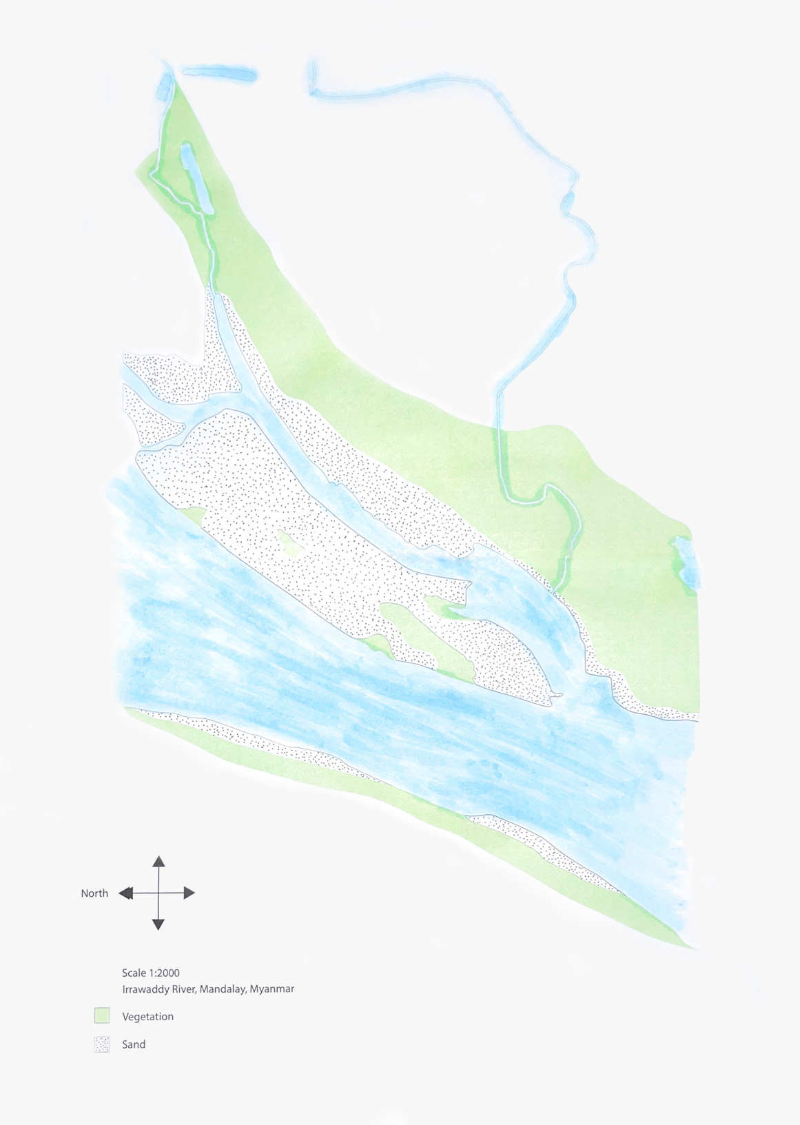
Scale 2: Finalisation Part A

_______________________________________________________________________
Scale 2: Finalisation Part B
A legend is added to the drawing. Retouched the drawing to lessen the dark areas. Instead of colouring the sand as orange, used stippling pattern to make the layer blend in better. The vegetation colour is also adjusted to lighter green.
_______________________________________________________________________
Scale 3: Iteration 1

_______________________________________________________________________
Scale 3: Additional Pictures
These are the pictures taken along the Irrawaddy River which is the river in scale 2.


_______________________________________________________________________
Scale 3: Iteration 2
For the scale 3, I chose light blue colour to overlay on the personal scale. After tweaking the capacity and colour, the pictures have light blue as an overlay colour.

_______________________________________________________________________
Scale 3: Finalisation Part A
In the first drawing, the base water map of scale 2 is layered and added a 30% opacity of light blue in order to make the pictures blend in. Finally in the second drawing, I added a picture with a opacity of 25% to emphasise the importance of the river for the villages living along the river as these people depend on the products of Irrawaddy river.


_______________________________________________________________________
Scale 3: Finalisation Part B
The previous drawing of scale 3 seems to be in good condition in term of colour, but the river and it's layers are missing. Therefore, the drawing of the river is brought up front, added some saturations on the drawing which finally makes the sketch pops up.

_______________________________________________________________________
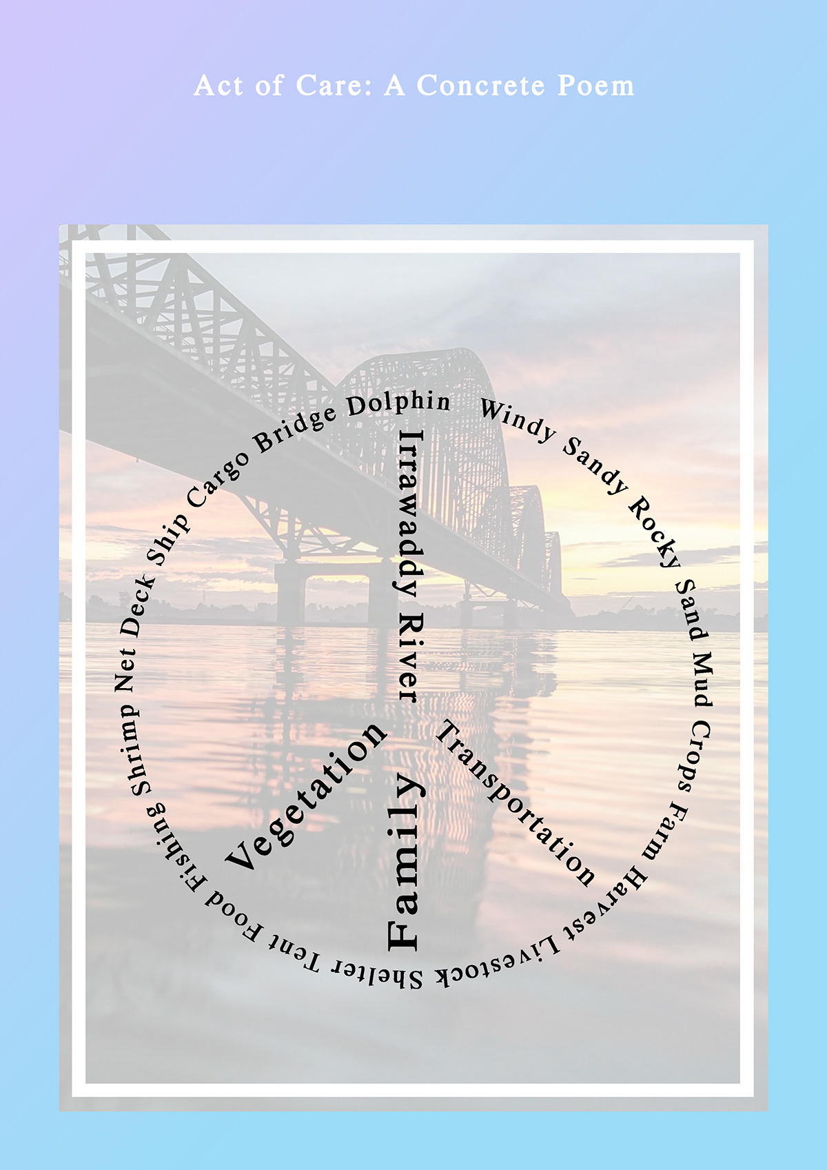
Scale 4: Act of Care
A poem for Irrawaddy river will mainly focus on the lives which are dependent on the river. Using nouns and adjectives, the poem will be shaped in peace logo to emphasise how peaceful the river is. The words that will be used for the poem relate to the situation of the river.